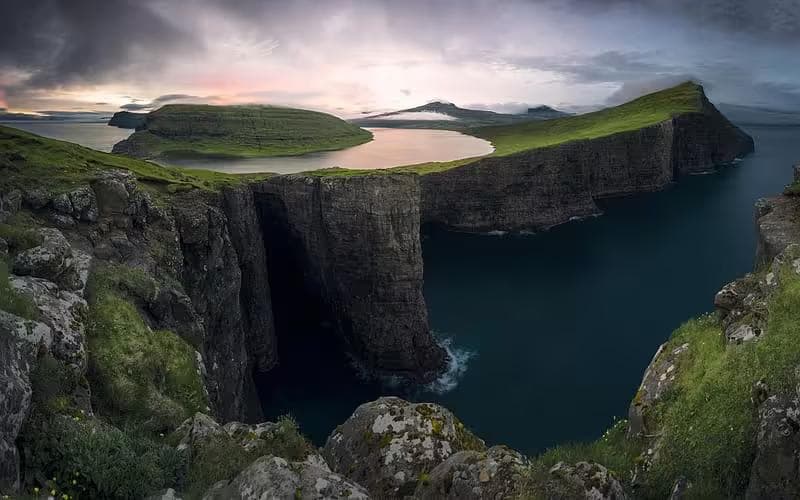
The Faroe Islands teach wind as a primary language. Not the brief, directional gusts of alpine terrain or the sustained lateral pressure of an Icelandic plateau — something more conversational than either, a wind that arrives from one direction, stalls, reverses, and arrives again from somewhere completely different within the same minute, as though the Atlantic is conducting an argument with itself around the island geography. Standing on the ridge above Gásadalur with the cliff dropping 400 meters to the sea on the western side and a wall of cloud advancing from the northwest at visible speed, the body learns something that no description fully transmits: in the Faroe Islands, the weather is not the context for walking. It is the terrain.
The archipelago sits at 62 degrees north in the North Atlantic, equidistant between Norway, Iceland, and Scotland — 18 islands of basalt and grass rising from one of the world's most weather-active stretches of ocean. The walking here is concentrated, technical by attitude rather than by elevation, and rewards trekkers who approach it with the same seriousness the landscape demands. Four days covering the most significant routes across Vágar, Streymoy, and Eysturoy islands delivers the full Faroese spectrum: sea cliffs, ridge traverses, lake overlooks, and the specific quality of a path that the grass has made genuinely slippery and the wind has made genuinely interesting.
01Arrival
Atlantic Airways operates direct flights to Vágar Airport from Copenhagen, Edinburgh, and several other European hubs. The airport sits directly on the island of Vágar — the itinerary's first walking day begins within 20 minutes of the terminal. Car rental is essential; the inter-island road and tunnel network connects most of the archipelago's main islands, and the trailheads for this itinerary require a car between days.
Base
Tórshavn — the Faroese capital on Streymoy, population 22,000 — is the logical overnight base for days two and three. Hotel Tórshavn and Airbnb options in the old harbour district both work well. Day one and day four are based on Vágar, where Hotel Vágar near the airport handles the first and final nights without unnecessary driving.
The Visit Faroe Islands trail registration system requires trekkers to register planned routes before walking. This is not bureaucracy — it is the emergency system that dispatches the volunteer mountain rescue teams when walkers do not return. Register each day's route the evening before. It takes three minutes and is taken seriously by the local rescue service.
02Day One: Gásadalur & Múlafossur
Distance: 10km | Elevation gain: 550m | Time: 5–6 hours
The first day walks the most photographed route in the Faroe Islands — the ridge approach to Gásadalur village and the Múlafossur waterfall, which drops from the clifftop plateau directly into the Atlantic 150 meters below. The route begins at the Bøur car park on Vágar's western coast and climbs the ridge via a path that the tourism authority has partially improved with stone steps — the improvement ends at approximately 300 meters, where the path returns to its original material: wet grass, basalt outcrop, and the specific uncertainty of a surface that provides grip until it does not.
Ridge Approach
The Ridgewalker GTX Boots face their defining test on this ridge. Faroese grass terrain is the category of surface that boots are built for and frequently fail at — the grass blades are long, flat, and oriented downhill by the prevailing wind, producing a surface with grain that grips on ascent and releases without warning on descent. The GTX membrane keeps the foot dry through grass that holds moisture for the full day, regardless of overnight rain; the boot's outsole compound provides the edge grip that the basalt outcrop sections require between grass stretches. On the descent from the Gásadalur plateau, the combination of wet grass and a 35-degree gradient is the specific condition where inadequate footwear converts a manageable descent into an uncontrolled one.
Múlafossur
The waterfall at Múlafossur drops from the plateau edge at the western end of the Gásadalur bowl — the water launches off the cliff lip and atomizes in the crosswind before it has descended 50 meters, arriving at the ocean as mist rather than water. In strong onshore wind, the atomization is complete within 20 meters of the lip, and the viewpoint at the cliff edge receives the spray horizontally. The Stormveil Shell Jacket is the layer that makes standing at the viewpoint for the 15 minutes the photography requires a viable proposition rather than a race against the cold. Its hood, cinched and sealed, deflects the spray; the membrane prevents the sustained mist exposure from penetrating to the insulation layer below.
The StormVault Dry Bag protects the camera and electronics from the Múlafossur spray zone — not from rain, which the jacket handles, but from the horizontal salt-water mist that deposits on any unprotected surface within 10 minutes at the cliff edge. Electronics in the Faroe Islands require dry bag protection from the moment the coastal walking begins, not from the moment it rains.
The cliff edge at Múlafossur is unfenced, and the grass at the lip is undercut by erosion in several sections that are not visible from the approach. Stay 3 meters back from the visible edge. The wind gusts at this point are strong enough to affect balance — the Traverse Trekking Poles provide the stability platform that makes the cliff edge viewpoint safe rather than reckless. Do not approach the lip without poles planted.
03Day Two: Sørvágsvatn & Trælanípa
Distance: 8km | Elevation gain: 300m | Time: 4–5 hours
The second day crosses to Sørvágsvatn — the largest lake in the Faroe Islands, famous for the optical illusion that makes it appear suspended above the ocean when viewed from the Trælanípa cliff. The reality is that the lake sits at 30 meters above sea level, its western edge ending at a cliff face above the Atlantic — the illusion is produced by the viewing angle from the Trælanípa path, which compresses the apparent distance between the lake surface and the ocean below it.
Access & Registration
The Sørvágsvatn trail is managed by a local farmer under a paid access system — DKK 100 per person — that funds the path maintenance and the ongoing land rights agreement. Pay at the registered entry point before the trailhead. The path is well-maintained by Faroese standards, and the farmer's investment in its upkeep is visible in the stone-reinforced sections above the lake's northern shore.
Trælanípa Cliff
The viewpoint at Trælanípa — at the cliff edge where the lake appears to overflow directly into the Atlantic — is the itinerary's most technically exposed position. The path to the viewpoint traverses a grass slope above the cliff at a gradient that requires the poles in both hands and a deliberate choice of foot placement on every step. The wind at Trælanípa arrives offshore — west-southwest, full North Atlantic fetch — and hits the cliff face at a speed that the sheltered lake approach does not prepare for. The Stormveil Shell Jacket and Traverse Trekking Poles function as a system here: jacket managing the thermal and moisture exposure, poles providing the stability platform that allows the viewpoint to be reached and used rather than merely approached and retreated from.
The Sørvágsvatn optical illusion is best photographed from the lower viewpoint at the cliff base, not from Trælanípa itself. The lower position creates the maximum apparent height differential between the lake surface and the ocean. Visit Trælanípa for the physical experience; descend to the lower viewpoint for the photography.
04Day Three: Slættaratindur — Faroe Islands High Point
Distance: 12km | Elevation gain: 880m | Time: 6–7 hours
The third day crosses by tunnel to Eysturoy island for the ascent of Slættaratindur, at 882 meters, the highest point in the Faroe Islands. The route begins at the village of Eiði and climbs the island's central ridge on a path that is clear in good visibility and navigationally demanding in the fog that Slættaratindur generates independently of the wider archipelago weather.
The Ascent
The lower section through the Eiðisvatn lakeside meadow is the last genuinely flat terrain of the day. Above the lake, the ridge narrows and steepens through a series of false summits that the cloud conceals and reveals on its own schedule. The Faroese ridge in cloud is a navigational environment where the path visibility extends to approximately 15 meters, and the GPS track is the primary orientation tool rather than landscape features. Download the route to a dedicated device before departure — Komoot and OutdoorActive both carry accurate Slættaratindur tracks — and carry the device with a full charge. The StormVault Dry Bag keeps the device dry through the sustained ridge mist that deposits moisture on every exposed surface, regardless of whether rain is technically falling.
Summit Conditions
The Slættaratindur summit at 882 meters is the most wind-exposed position on the itinerary. The summit plateau is flat, featureless in cloud, and subject to gusts that the ridge below channeled and compressed before releasing onto the open top. The Traverse Trekking Poles are planted wide on the summit approach — not for gradient management but for lateral wind stability on a path where the gust pattern is irregular enough that the next step's footing cannot be assumed from the previous one's. In clear conditions, the summit delivers a 360-degree view of the full archipelago — all 18 islands simultaneously visible, the Atlantic in every direction, the inter-island bridges and tunnels threading the water between them. In the cloud, it delivers 15 meters of grey and the satisfaction of having reached it anyway.
Slættaratindur, in sustained winds above 25 m/s, is a seriously exposed position with no shelter below the summit. Check yr.no for Eysturoy summit-level wind forecast the morning of the ascent. If the forecast shows gusts above 20 m/s, substitute the lower Eiðisvatn ridge walk (500m), which provides shelter from the worst of the northwest exposure. The summit will still be there on a calmer day — the archipelago's weather window is short but real, and waiting a morning is a better decision than the summit in conditions that make it dangerous.
05Day Four: Kallur Lighthouse, Kalsoy
Distance: 10km return | Elevation gain: 400m | Time: 4–5 hours
The final day requires a ferry crossing to Kalsoy — a narrow island north of Eysturoy, 6 kilometers wide and 20 kilometers long, connected to the main archipelago by the Kalsoy ferry from Klaksvík — for the walk to the Kallur Lighthouse at the island's northern tip. The ferry runs three to four times daily; the 9:00 am crossing from Klaksvík arrives at Syðradalur at 9:25 am and provides enough time for the return walk and the 3:00 pm ferry back.
Kalsoy Ridge
The Kalsoy path from Syðradalur to the lighthouse traverses the island's central ridge — a narrow spine of basalt with the Atlantic visible on both sides simultaneously, the drop to the west steeper and more immediate than the eastern flank, the path maintaining the ridge line between them with a commitment that feels architectural. The grass on the Kalsoy ridge is the steepest and wettest of the four days — the island's narrowness means that both flanks receive full Atlantic exposure and the grass surface holds moisture from the sea air independently of rainfall. The Ridgewalker GTX Boots and Traverse Trekking Poles complete their four-day working relationship on this ridge in the conditions they were designed for: wet grass, lateral exposure, and a path that requires consistent attention rather than occasional caution.
Kallur Lighthouse
The lighthouse at the northern tip of Kalsoy stands on a promontory above the Atlantic on three sides. From the lighthouse base, the ocean in every forward direction extends to the horizon without interruption — no islands, no ships, no land features between the Faroe Islands and the Arctic. The wind at the lighthouse is the full unmediated North Atlantic wind — no valley geometry, no ridge channeling, no island shelter. It arrives at whatever velocity the ocean is producing that day, and the correct response is to lean into it, plant the poles, and look north until the scale of the water becomes something the mind accepts rather than resists.
The ferry back to Klaksvík at 3:00 pm and the drive to Vágar for the final night close four days of walking in a landscape that gives nothing easily and takes nothing for granted. The archipelago from the Vágar Airport departure gate — visible through the terminal windows, the ridges still cloud-capped, the sea below them still moving — looks exactly as difficult as it was, and exactly as worth it.
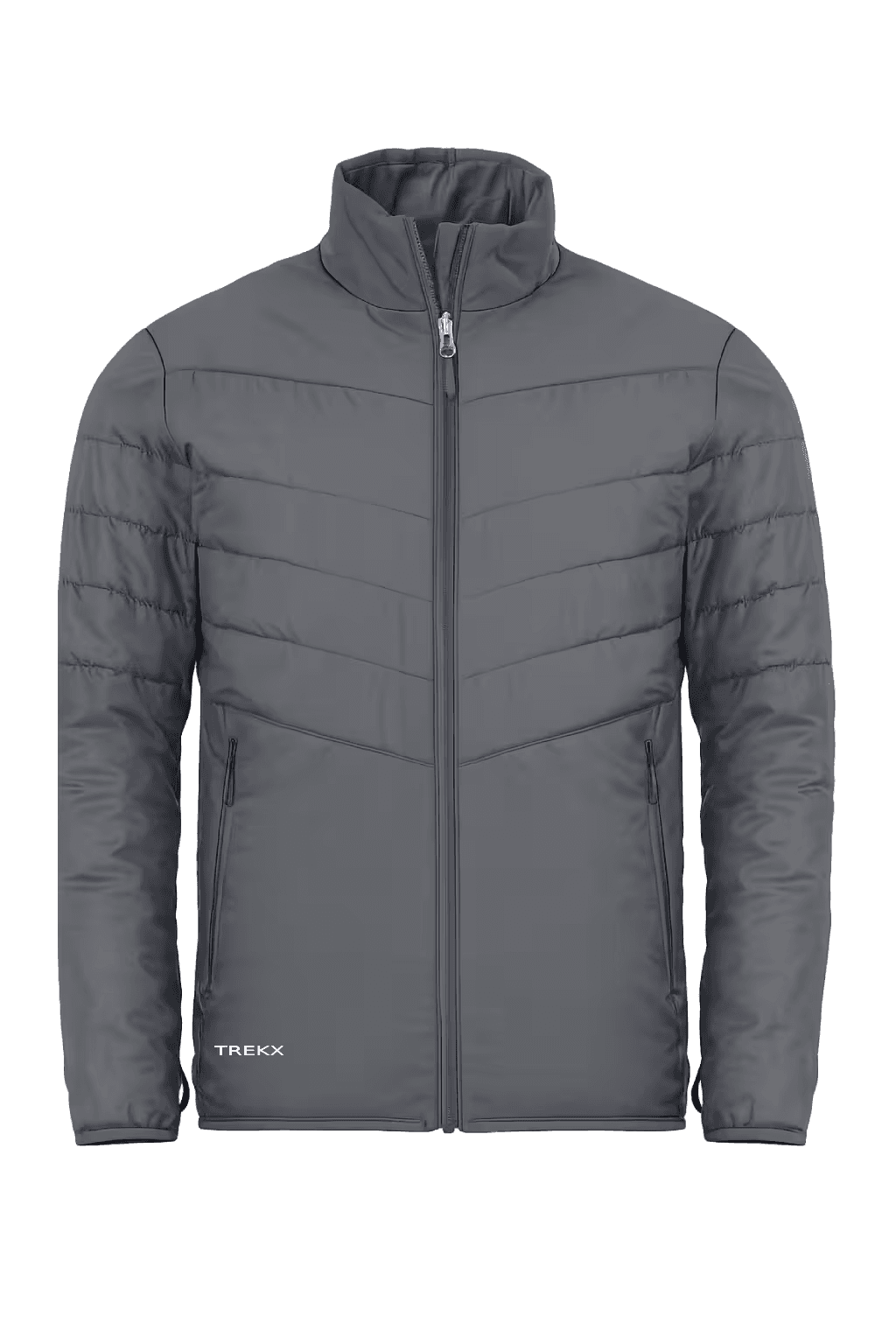
Stormveil Shell Jacket
Deployed at Múlafossur spray, Trælanípa offshore wind, and Slættaratindur summit exposure where sustained mist and Atlantic wind make an unprotected upper body a cold management problem
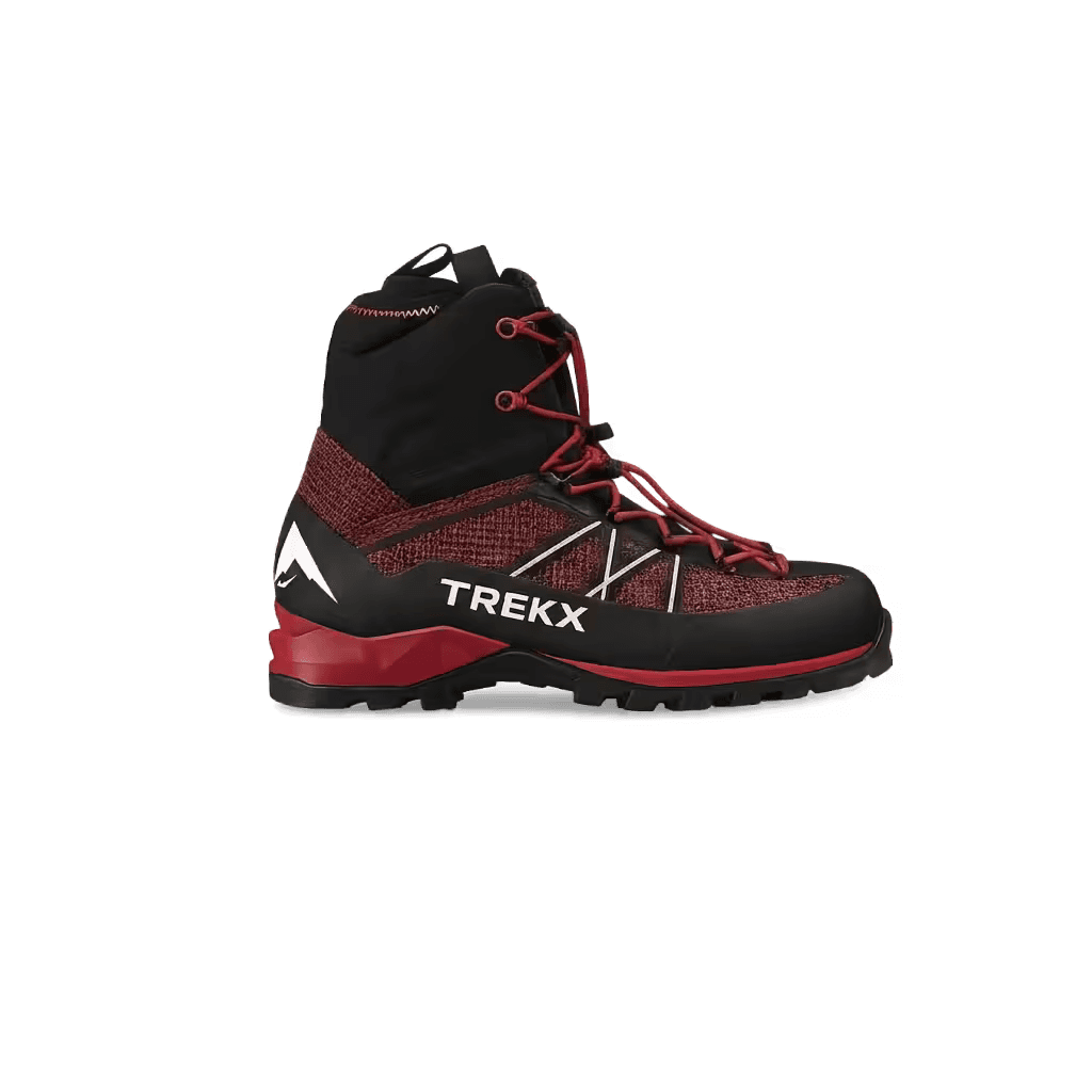
Ridgewalker GTX Boots
The boot that converts the Gásadalur descent and Kalsoy ridge from a liability into manageable ground across four consecutive days of perpetually damp surface
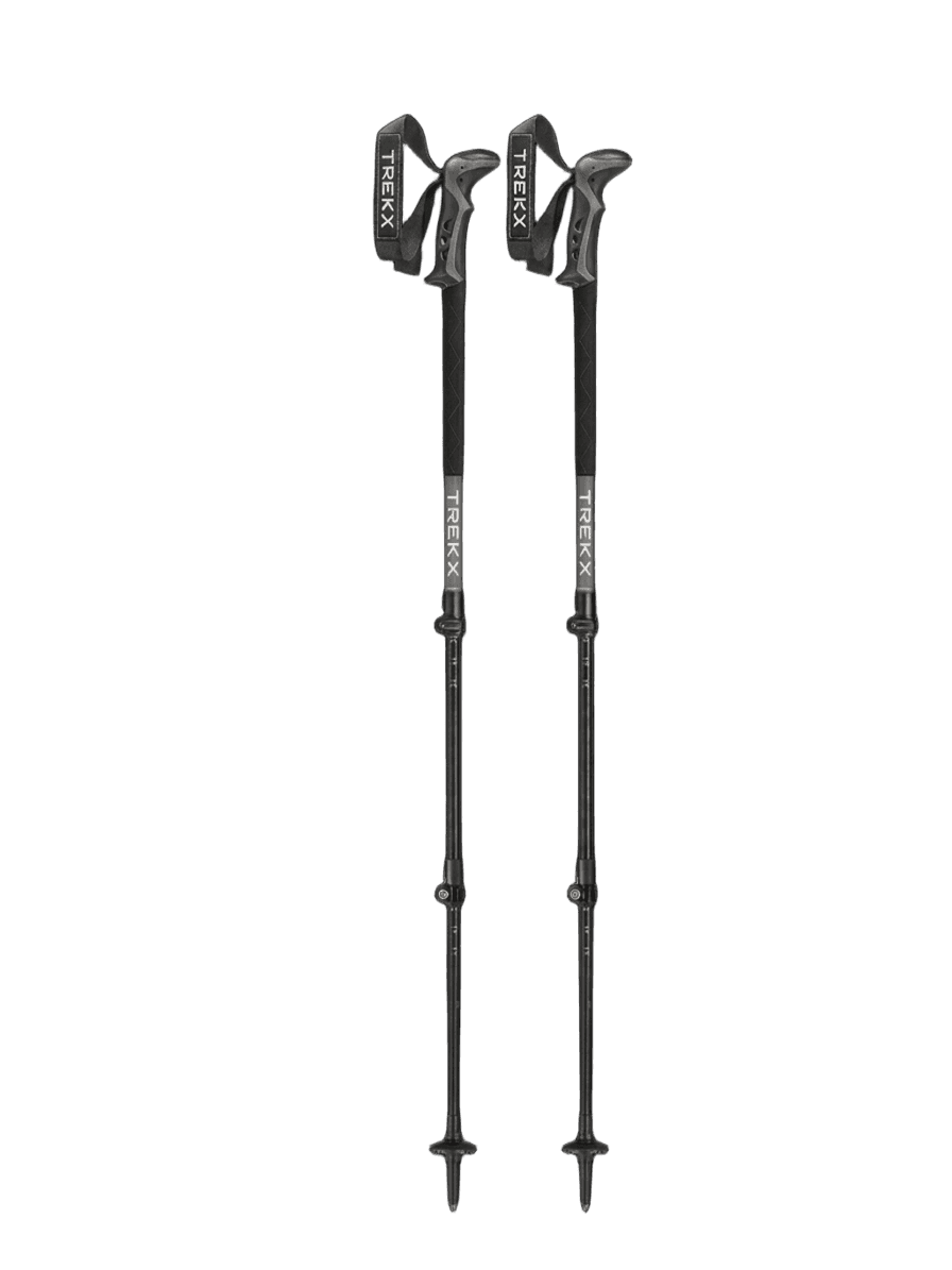
Traverse Trekking Poles
Provides the stability platform that Atlantic wind gusts require on exposed cliff edges and open ridge
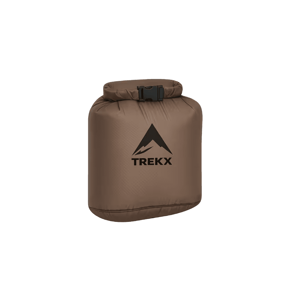
StormVault Dry Bag
Protects electronics from the horizontal salt-water mist that Faroese cliff exposure deposits on unprotected surfaces